
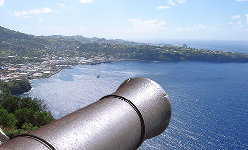
 Located on Bershire Hill, Edinboro, construction of the fort began in 1763 when the British recovered St. Vincent. It was finally completed and named in 1806. It was named after Queen Charlotte, wife of King George III. The Fort is on a ridge 600 feet above the sea, giving a magnificent view across Kingstown and the Grenadines.There are interesting paintings of the Black Caribs’ history by Lindsay Prescott in what used to be the officers’ quarters in the Fort; only a few minutes’ drive from Kingstown.The Fort is now an Historical site.
Interestingly unlike most forts in the Caribbean it was not used to protect the island from naval attack. Rather its purpose was to protect against attacks from inland by the Caribs and French.
In its heyday it boasted 34 pieces of artillery and had barracks for 600 men. It should be noted that the fortification consisted of more than just the main ramparts and barracks at the crown of the hill. (See attached drawing.) A drawbridge located some 250 yrds or so below the gate way of the citadel marks the front end and there were buildings along the way from there to the gate. Around the foot area below the barracks were a number of other structures that were part of the fort. Natural deterioration and hurricanes have erased most traces of these structures.
In the present time one of the key points of a visit to the fort is the view of Kingstown, Mt. St. Andrew, Ottley Hall, and the Grenadines all in a single 360 degree turn. Some rooms are now used for interpretation of history and culture of the country.
2006 represents the 200 anniversary of the naming and final commissioning of the fort.